I'm really not sure how to write this post. I wanted to come up with some awe-inspiring title that would capture the emotion and feelings of what happened on this hike. My mind just goes blank. I have told this story so many times and I have pictured and relived the events of that day over and over and yet I can't seem to write it out. On the left side of the main page of my blog is says "This blog will be about my experiences, the places I go, how I rated the trail, and most importantly about my reflections." I suppose I should stick to that formula and just write it all out. I'll try to write everything I remember if for no reason than a reference.
As I had stated in the last post, this winter break was suppose to be "Leland's winter of hiking." I was going to hike at least once a week and travel all over Southern California. I wanted to revisit Joshua Tree and I was thinking of a 2 day trip to Death Valley. Mother Nature had other plans. The first two weeks of my break were rained out. It rained nearly everyday and though I enjoyed my hike in Switzer Falls, I had no desire to repeat that day. So I waited and finally the forecast gave me good news for Thursday, December 20.
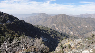
Most people had left for the break but for different circumstances I remained along with my good friend, David. We both love hiking and we decided that we would get together and get out onto the trails. I looked through my hiking trail books for the Angeles' mountains and picked out what seemed like a moderate trail with great views. The Mt. Williamson trail over looks the Mojave, the Devil's Punchbowl, and the San Andres Fault. It's high into the Angeles National Forest with an elevation of over 8000'. Medium difficulty. Short distance. Great views. It met all my criteria for a hike. I even thought with all the precipitation lately that we might find some left over snow.
Dave and I did not find some snow. We found a winter wonderland. The roads became icy and we had to turn around a couple of times before we finally found the unmarked trail head at mile marker 62.50. There are actually two trail heads. one at mile marker 62.50 and one about a mile further. We found the other one first but decided not to try it because (I kid you not) we thought it was too dangerous. We both hesitated going onto the trail. We didn't want to risk anything nor did we think the hike was worth our lives. After some prodding from both of us we decided to try it until it got too dangerous. I repeatedly suggested that "we were both idiots for doing this" as I continued forward on the trail.
The trail was pristine. The only footprints in the snow were from some sort of animal. No human has stepped foot on that trail for a few days. This was a true adventure. The trail quickly comes to a fork in the road. The trail to the right switchbacks up to the west and the left was an even path that goes east. David, who was wearing running shoes, took a step on the western trail but thought the ice on the switchback would prove too much for his inadequate footwear. Me, fearing that the hike would be cut short before it got started, decided to go left and lead the way. I was wearing new hiking shoes and could handle the snow and ice much easier than Dave. I blazed a trail for Dave to follow and we walked about a mile in the snow until we could no longer proceed. Below us we could hear a creek and when the creek finally became visible it offered a glimpse into a peaceful place. It made me think of Robert Frost and my own desire to escape from the stresses of life. David admitted that he wished we could go down to the creek but there would be no way up. I sarcastically laughed and said "feel free to take the slid down." We continued on for a little while until we could no longer proceed.The trail became so covered in snow that it was no longer visible. We decided that we had gone as far as we could and that we should call it a day and return to conquer Mt. Williamson after the snow had melt. We took amazing pictures of the snow covered forest. It was truly beautiful. It was a great, short hike in the snow and that is where it should have ended.
But that is not where it ended. On our way back down the trail David, who was getting pretty good at walking in the snow or at least in following in my footsteps, said "hey, we're getting pretty good at hiking in the snow." "I agreed. I was not satisfied with the hike and wanted more. I thought "surely if I can make some footprints for Dave, then we can try going up on the Western trail." I did not let Dave in on this and just continued hiking. After he realized what I was doing he followed and thought that we could go on a little ways until it was too dangerous.
Our thoughts of danger were quickly distracted by the outstanding views that were even better than the ones on the lower trail. We worked our way up the switchbacks despite many instances where we should have turned back. I kept wanting to push forward. I thought if we could just keep going then maybe we can even make it to the peak. Why not?
The trail was getting narrower and the ice was getting worse. There was a particular place were I had made it past some ice. Dave hesitated to follow me and asked what the trail looked like around the bend. I lied, to Dave and to myself, that it wasn't nearly as narrow as this section was. He moved over to me, nearly missing a fall and then took a look at where the trail was going. David knew what I didn't want to admit. We had gone to far and tested our luck way too much. This was not going to happen. He tried to convince me that this was it. It was not worth the risk. I took a step forward to feel the ice and agreed. This would be the end of the trail for us. I took a picture, checked my watch which read 2:00 pm, and we turned around.
It immediately became clear that the descent would not be easy. It was as the footprints that I had made were gone and we were on a whole new trail that would have to be taken seriously. I tried to make a foothold with my shoe in the ice. Dave found a rock to help beat in the snow to help. It did. I crossed over that section of ice and then helped Dave pass. I began to work my foot on the next section of ice. Dave offered the rock to help me break in the ice but I didn't think I needed it. I told him "No, I have it." And then I slipped.
I have no idea how long I was sliding down the slope. I guessed the distance to be somewhere between 200 and 300 feet at an incline of around 60 degrees. Honestly, I have no idea. I didn't have a ruler or a protractor nor did it seem to matter. I'm sure with the accurate measurements it would make a really sick question in high school physics class. With that being said, I have no idea how long I was sliding. But it felt like forever.
My first thought was to grab into the ground. I clawed my fingers to stop myself from sliding. It didn't take long for me to realize how useless that was. I hit something and now I was sliding sideways. Maybe I could grab a root or something sticking out of the ground. Nope, that didn't work. I was not going to stop until the laws of nature saw best fit. I was powerless and all I could do was accept my fate. I would die. If I'm lucky I'll just break a femur or my neck.....wait....protect your neck. Ok, if I want to protect my neck then I should curl up into a ball. Or should I try to stay flat? Think, Leland. When you went white water rafting in Gatlinburg in 2005 they told you to curl up to protect your neck if you capsized I wonder if that transfers over to sliding down mountains. I'll try to curl up. Now I'm rolling. I can see a patch of plants coming. And the next thing I knew I was stopped next to a fallen tree towards the bottom of the ravine. I do not remember hitting the tree nor did I feel it. But that seems to be the only option.
I stood up. My winter coat which I had been wearing unzipped had completely come off of me except for the wrist of my right arm. I immediately threw on everything that I could. I wasn't sure how cold my body was after sliding in the snow. That's when it occurred to me that I could move. My neck worked find, I could feel all of my appendages. Except for a pain midway up the outside of my right calve, I could walk fine. I was shocked. Just seconds earlier I thought I was going to die and here I was standing up. I looked up into the sky and said "God, you just saved my life. I should be dead but I'm not. Thank you."
I yelled back up to Dave. "I'm alive and I'm ok. Please send help." He yelled backed, "what do you want me to do?" "Go get help! I'm going to try my cell phone." I reached into my pocket and pulled out my phone. There was no signal. I tried to do an emergency call but it wasn't working. My only hope of rescue was Dave and his darn, running shoes. I then checked my pockets to see what I had. My wallet and keys were still there but my camera was gone. I thought "well the blog will suffer but I don't care about the camera right now." I opened my back pack and got out my cheap survival kit. I had never opened it before so I was only half-sure what would be in there. There was a multi-tool, a small flashlight, some water proof matches, some band-aides, and a whistle. I took the whistle out and started blowing it in hope that there might be someone else within earshot of the whistle. Dave responded, "do you need me. I heard your whistle." I was irritated by his return though it was completely logical on his part. I just screamed back "No! GO GET HELP!"
I finally began to think somewhat clearly. I could tell my arms and hands were cut up pretty bad. My right leg on my jeans were torn open. My stomach was stinging. At this point I thought that I might be getting frostbite on my stomach. I had looked at it and it was purple. Later I would realize that it had just been covered in blood. I looked down into the ravine and it looked like a nice place to set up camp and wait for rescue but I still was gun shy about walking on my leg. I waited a little while longer. I looked again and noticed that the sun was shining onto the opposing side of the ravine. It looked warm and I would rather wait there for help than just standing here next to the fallen tree. I got up my courage and carefully walked on the land that was not meant for human feet. It was uneven and I stepped into a hole that had been covered by snow. I finally made it to the sunshine. It felt good to be in the light. I just hoped that rescue would come before dark.
I wondered what was happening with Dave. Would he be able to make it down the trail without slipping off the side? Would he be so lucky if he did slid. Oh, God, please don't let him slip. I couldn't stand the thought of Dave dying. And if Dave slipped, how long would it be before anyone noticed my car? Would anyone stop at the sight of a parked car and think to call rescue? I always post on Facebook where I'm going just in case something happens. Well something happened, how long would it be before someone things back to the status and put two and two together? Would I be able to survive the night. I was starting to panic. I couldn't do that. I started to pray for Dave's safety. And then I thought of my loved ones. I just wanted to tell my mother that I loved her one last time. I thought of my family and my baby niece who I wanted to see grow up. I thought of Jessica who had meant so much to me for so many years. I had to survive. Not for my sake but for the sake of those who loved me. I began to gather sticks. I had a hatchet that Brian and Kelly had given me as a gift for officiating there wedding. I used it to cut off some branches from another fallen over log. i put the bundle of the driest looking sticks I could find on the ground, took out the matches, and tried to start a fire. It wouldn't work. The wood had been covered in snow and was not going to catch fire.
I tightened up my jacket even more. It was now 4:00 pm and still no sign of rescue. I had about 1:30 hours of sunlight left. I looked over to my right and there it was. That freaking creek we had noticed earlier. Perhaps, if I could follow the creek and continued to yell for help and blow my whistle, then I could meet any rescuers half way. Surely help was coming. Help had to be coming. I had to move. I couldn't just stand there and do nothing. What if help wasn't coming. help had to be coming. I have to move. I started walking down the banks of the creek.
This is untrammeled wilderness and I was essentially winging it. I would follow one bank as far as I could, then cross the creek until I could go no further, then cross it again. The creek was cutting through hills because I would have to slide down miniature slopes to continue on, what I did not realize that as I proceeded down the slopes, I was cutting off any chance of me going back. I finally slid down a slop into some bushes. When I hit the bushes I noticed what was on the other side. It was a 10 foot drop down a waterfall. I was lucky to not have busted through the bushes. I crawled up to a tree where I could hang on.
I began to map out my next move but there wasn't one to make. I could not make any safe move. I was stuck there. I checked my cell phone for the time (my watch was ripped off at some point during the slid). It was 5:00. I had about 30 more minutes of sunlight and I couldn't spend my night here, hugging onto a tree. I took a deep breathe, tried to remain calm and reevaluated my situation. Surely I could do something. I could slid into some branches, where I could then crawl up and then maybe slid down a pretty good ways into the creek. However, that slid into the creek was much further and much steeper than I was willing to risk. I needed help and I needed it now. I had no idea what I was going to do. Out of frustration I screamed "Father, God, send help!"
Then I heard it. I heard a thump. Then is sounded like yelling in the distance. I couldn't make out what it said but it sounded like a person. I yelled and blew my whistle as loud as I could. The voices got closer and closer. I could finally here my name. I yelled "I'm at the waterfall by the creek. I'm stuck and need help."
I couldn't see anyone and but I could here a man's voice. I could only make out about half of what he was saying. He asked it i was hurt and if I could move. Out of excitement and a desire to get closer to help i decided to make my next move. i slid down to the branches but in stead of sliding down to the creek I pulled myself up the another tree.
I could make out the officer who claimed to be from Los Angeles Sherriff's Department. I couldn't make out his name but it sounded like "Rice." I settled for calling him Ryan until I could meet him face-to-face. He informed me that an helicopter was coming and to wave whatever I could at it. I did so. When that didn't work I shined my weak flashlight at it. It was now dusk and the flashlight stood out just enough that the helicopter saw me. They were scouting out the area around me and trying to figure out what they needed to get to me.
I waited as night fell for my rescuers. I kept calling up to "Ryan" to see if he was still there. While I was standing there i dug my shoes into the slope and tried to make it across the slope. This is by far the stupidest thing i did all day. But I wanted out. I slowly made my way across the slope while holding onto the branch. I finally saw the headlamps slowly making there way toward me. I made a leap of faith and crossed the slope into some more trees.
Two men, Joe and Mike, came within sight. They had ice picks and clampons that helped them cross the slopes. They looked as if they were gliding across the slopes. It was a miracle. When they got close to me I said "Hey, how are y'all doing tonight?" They seemed more interested in how I was doing. I then asked what I had been wondering since the fall "had Dave made it? Was he the one who had called emergency or had someone noticed my car?" Joe informed me that "my friend was safe." I tried to be in good humor as they tied a rope around me, making a harness. A third man, Doug, came to offer his assistance.They told me what they were going to do. They were going to tie a rope around the tree I was hugging, Joe was going to cross the slope and tie the rope to another tree and then they were going to harness me to the rope and they were going to help me across. Mike asked me if I was ok with this which I agreed. He replied "good because that's what we're going to do." I laughed but then admitted that I was terrified. All of my emotions from the day were beginning to come out. As they were getting me ready Joe said "Oh, by the way, my friend want's you to know that his name is "Bryce" and not "Ryan."
Doug helped me across to the other side. Mike then crossed and we repeated the entire process on the next slope. They had me sit on a stump, as they prepared the next contraption. As I was sitting on the stump I realized I couldn't feel my butt. It had gone completely numb. I told this to Joe. His response was "don't worry, I can't feel my toes." This did not ease my fears to say the least. I then realized that this was going to take a much longer time than I hoped. I asked one of them to radio dispatch and have them call my work to let them know I would be unable to make it to my 8 pm shift. They did.
The next contraption was a lowering system. They tied me to a tree and myself and Joe repelled down the side of the slope. this was actually a lot of fun and Joe told me people pay a lot of money to be able to do this. I laughed and decided this would make a great story. When we reached the bottom, Joe told me that the worst part was over and now it would be a breeze getting me out of here. Joe, I found out, was a lier.
We waited at the bottom of the slop where Judy repelled down and gave us a harness and some rope. She then climbed up as Joe got me ready. The way the contraption worked was I was harnessed to a rope. There were 5 people pulling me up as I crawled along the side of the slope. We got ready and started. 5 steps into it, the top side had to stop in order to fix a rope. All of my adrenaline that I had saved to put into this was gone because we had to break. This completely threw me off. The rest of the way was long and hard as I would go 30 feet and have to stop for break. Within the last 30 feet, I had to stop for a break. I could see and hear Bryce. The cheered me on as I made it to the top. I feel to the ground as I tried to catch my breathe. I was exhausted.
When I stood up, Bryce asked me several questions and checked me for a concussion. I answered the questions exceptionally well. He asked me where I was "I told him exactly and even told him which trail number it was in the book I had bought and where I had bought the book. This satisfied him. I looked at joe and said "you just saved my life. "He smiled and said "it's out job."
I should take this moment to say that it is not all of their jobs. Bryce and Joe work for the LA sheriff's department. Everyone else were members of the Sierra Madre Search and Resuce and Montrose Search and Rescue. These are both volunteer groups. These men and women do what they do for fun.
Joe and Bryce slowly walked me off the trail. I recognized this as the lower trail that Dave and I had originally hiked. Bryce stayed on my outside and was not going to take any chance of me falling again. they then informed me that the news was waiting at the trailhead. Which I thought "oh great, my jeans are ripped and I'm going to flash everyone." They also told me that Dave was waiting at the trailhead. I had assumed someone would have driven him home but now I felt bad that he had been waiting in the cold for the last 7 hours.
As I turned the last corner I saw Dave. I stopped and said "Getting better at hiking in the snow, my ass." Everyone let out a laugh but Dave continued toward me. I gave him a hug and emotions overran me as i told him how glad I was that he was alive. The news then approached me but Joe and Bryce, who were also paramedics, wanted to look me over. They cleaned my wounds and looked me over. They said that I would be fine and they didn't think my leg was fractured. I did an interview and thanked all the rescuers again. I then gave Dave the keys to my car and climbed in the passenger seat. I blasted the heat and we talked about the miracle that just occurred how would we explain this to our families, and whether his girlfriend would kill him or not. When I got home, I took a hot shower, sat down, and called my mom, and told her that I loved her. That would not be the last time.
It has now been two weeks since the accident and my wounds are healing up. My hands look a lot better and my stomach has scabbed over. I'm still in a lot of pain but I'm glad to be alive. I truly think God performed a miracle. I don't know how I survived the fall nor do i think I would have survived the night. But I did and I was rescued. I owe my eternal gratitude to the men and woman of the search and rescue team, and of course, to my friend Dave.
Despite all of this, it has not killed my desire to go hiking. Once I have recovered I will get back on the trails, however I will always have a friend with me. Also I plan on conquering Mt. Williamson once the snow has melted. With the New Year I come with plans. I plan on hiking the Bridge to Nowhere and Mt. Baldy this year. So please keep an open eye to upcoming blogs and let me know if you would like to join.
Last note. As my camera was lost during my adventure I do not have any pictures to post. David did take a lot of pictures and I will post them if I can figure out how to get them off of his facebook. Also, if anyone wants to offer me a new camera.....I wouldn't say no.
Edit: For anyone who wants to see the news broadcast, here is the link
Friday, January 4, 2013
Cougar Crest Trail December 8 2012
San Bernardino Forest:
Cougar Crest Trail

I'm just going to be honest, I waited way too long to write this blog. It has almost been a month and way too much has happened this break for me to have a good memory of this trail. I'll try my best.
This hike was officially my first hike in the San Bernardino Forest is was suppose to be the kickoff to "Leland's winter of hiking." This was also my first non-solo hike since my trip to Joshua Tree. This time my friends, Steve, Terry, Sarah, and Mike joined me. Much to Terry's dismay, we all crowded in Steve's car and began the 2 hour trip to Big Bear. The drive up is beautiful and the world transforms from the Los Angeles metropolis into a quiet, little, mountain town. There is a major resort up here and it is quite obvious why Big Bear is such an attractive escape for the Angelenos.
You do not have to pay for parking because you actually park at the ranger station and follow a paved trail for about a quarter mile to the trail head.

The first mile of the trail is much worse than the rest of the trail, though it is overall not that bad. The trail starts off as moderate but after the first mile it is an easy trek through the forest. It was nice to have some good conversation while hiking and I enjoyed the company. The trail was pretty busy the entire time.
As we continued the climb the trees would open up and spectacular views of Big Bear lake would appear. After awhile the trail opens up to an unobstructed view and even park benches were added to take it all in. This is a great place to stop and enjoy nature.

Mike and Terry loved it so much (or were sick of walking) that they decided to stay here while the rest of us continued on. Sara rediscovered her love of trail running which left Steve and I to hike up the trail together. From the benches it is only 5 or 10 more minutes to the intersection of the Pacific Coast trail.

This is where we made our mistake. From this point you can turn right and head up a mile to Bertha peak. Steve and I thought we had reached our final destination and returned to the rest of the group. I didn't realize until later that we were suppose to continue on. Oh well, we still got to enjoy great views of the lake below and I had a blast enjoying hiking as a group activity.
i really enjoyed this hike. It is an easy hike once you get into it and offers great views of the lake. I look forward to visiting Big Bear Lake more in the future if I can just find the time to get out there.
Thursday, November 15, 2012
Hike So Hard, Park Rangers Want to Fine Me. First They Gotta Find Me
Vetter Mountain Lookout

On November 11 I proved my bad boy status by hiking up to the Vetter Mountain Lookout. Why am I a bad boy, you ask. Well, it turns out this trail is closed. Ladies, please, not all at once. Reckless bad boy aside, this trail ended up being an easy hike with amazing views at the peak.
Getting there is simple. You just take the 210 to the 2 and drive up the 2 for 24 miles. You will see the Charlton Flats picnic area sign on the left. Pull into the area and follow the road left until you get to a closed gate. Park along the side of the road and the trail head is marked by a sign. Just to the right of the trail head sign is a sign that warns hikers that the trail is closed to all and violations are punishable. Not everyone is such a daredevil as me and I am not suggesting that anyone go out on the trail. I take no responsibility if you do decide to hike this trail and end up with a hefty fine.
The hike up to the peak is only 1.4 miles and the first mile of it twist and turns through valleys between hills. The trail is very overgrown and not kept up. There were a few moments when I had to move fallen trees out of the way in order to proceed. Again, the trail is technically closed, so I can't blame the park rangers for not cleaning it up. A lot of the plants have thorns on them and I got scratched up pretty bad. It's been 5 days and I'm still finding random scratches......manly scratches. Ladies, ladies, I'm trying to write a blog here.
 |
| For comparison, these plants were coming up to my chest. |
I did some research and as far as I can tell the trail is closed due to some fires that ravaged the area a few years ago. This is to be expected in the San Gabriel mountains and is not my first encounter with an area where the trees were burnt. I read a website at Vetter mountain and one of the comments mentioned how the trail used to be full of pine smell but the smell is gone. This makes me sad for I would have loved to have seen the massive pine trees. In stead, what I got was this.

Now don't get me wrong. It was beautiful in it's own way but nothing compared to the forests of Switzer Falls or Waterman Mountain. I kept walking until I reached a dead end. It looked like the trail narrowed and went up the side of a steep hill but just ended. This didn't seem like it could be the end of the trail and I certainly didn't see any lookout tower. I decided to climb the hill to see if the trail veered off. I spent 15 minutes working my way up this hill by climbing rocks and grabbing burnt branches. When I finally made it to the top there was not trail in sight. I was extremely disappointed, especially after all the extra work getting to the top of the hill, just to reach a dead end.
 |
| If this doesn't look like a pathway to you then you are right. |
I took a few pictures from the top and decided to just head back home. About 4 minutes on my way back I realized that I had made a wrong turn. I had turned left up a river bank where I should have stayed right on the trail. I felt really stupid but it is important to remember that I'm still an amateur. I started back on the trail having wasted a good 25 minutes. I was immediately rewarded for my perseverance because turning the bend revealed jaw dropping views of the mountains.

I continued up the switchbacks which are much steeper than the first part of the hike but nothing compared to some of the switchbacks I have tackled on previous hikes. Towards the peak you can finally see an outhouse and the Fire Lookout Tower. At the peak there are a few dirt roads that lead around the area and even steps to help you get up to the top. The view from the top is amazing and totally worth the first part of the hike.

Vetter Mountain Lookout Trail is a very short, easy hike with a huge payoff. If this trail was not closed and well maintained I would highly suggest it for beginner hikers who want something easy but still want great views. It is short and can easily be finished in an hour and a half, provided that you don't get lost. The last part of the trail is much more interesting than the first part but it is worth the journey. I imagine it was a beautiful place to hike before it was burned down.
I want to finish this post with a thanks to my readers. I honestly have no idea who reads this blog but I hope you enjoy reading it as much as I enjoy the hikes. Which brings me to my next point. If you want to join me on a hike then please let me know. I'm been doing a lot of solo hikes which is pretty dangerous and I wouldn't mind the company. Also if you have any trail suggestions then please let me know either in the comments or facebook. I'll finish this blog with some advice that I have heard for new hikers. If you are like me, and have trouble with some of the steeper parts of the trail. You can train for it by walking up stairs without using the handrail. I have no idea of this is true but it sounds like a good idea to me.
Saturday, October 27, 2012
Waterman Mountain Trail.
Waterman Mountain:

On October 21, 2012 I hiked up the Waterman Mountain trail and it is a wonderful hike. The majority of the hike is very easy and only the last 1/10 of a mile is strenuous. I recommend this hike to everyone that can find the time to go out. The trail is about 2.5 miles up to the peak and takes about 2.5-3 hours to complete.
In order to get to the trail head, take the 210 to the 2 and drive north for 34 miles. You will pass the Waterman Mountain ski lift on the right and drive about a half a mile to the 58.02 mile marker. Park on the open area on your left and cross the highway.
Here is where I got confused and almost ended my hiking day. The trail begins at a pretty steep incline and then immediately forks. I did not see the trail going left and instead went right. The path up towards the right leads to nothing. It is an interesting little clearing but has no trail in sight. I walked around this area for about 20 minutes looking for a trail. I had started late in the day and if I was going to beat nightfall I had to hurry. I made my way back to the car, drove back to the ski lift , looked for a trail there, and decided to try one more time. I had done plenty of research on the trail and all my research had given similar instructions to what I posted above. All of my sources said that the trail begins very gently. This incline is about as gentle as a porcupine and surely this couldn't be it. I looked at the trail head again and this time I noticed the gentle trail shooting off to the left along the highway.
The trail ascends very easily and the first .75 of a mile is nearly flat. After about a .2 of a mile I crossed an intersection. The trail keeps straight but if I had turn left I would walk right to the highway. After a few minutes I ran into some hikers returning back to their car. They warned me that there was no way I could make it back before nightfall and should turn back. I decided that I would continue for awhile and then turn around. I told myself that I would turn back when the trail started to get steep.
This trail is climbing through the woods and most of the views are blocked by pine trees. It seemed like a more stereotypical hike than the two previous trails that I have taken. However, about 1.5 miles into the hike I reached a point where the trees subside just enough to where I caught a breathtaking view of the National Forest Wilderness.

After this view the trail begins to get a little steeper as it switchbacks up the mountain.Though it was a little more steep than the first half of the trail, it was still very easy even for an inexperienced hiker like me. After some time I came to a sign that points the trail going to the left and the summit is only 3/4 of a mile away. Hikers have the option of continuing to Twin Peaks but I was running out of time and I was so close to the summit now.
I had abandoned any idea of turning back before reaching the summit. I wanted to cross this peak off my lift and I had come so far. So I continued up the last 3/4 of the trail over a nearly flat trail. It seemed like that final part of the trail was going to be very easy. And then I came to the very last part of the trail. I could see the peak but in order to reach it I had to travel up a very strenuous incline. I had to revert back to my run up 15 yards and then take a break for air and then repeat strategy. This incline was quite difficult but I eventually made it up.
The summit is not spectacular because it is covered in pine trees which block most of the view. I walked down a few more feet to get a better look and take some pictures. It was then that I noticed that the sun was beginning to set and I still had to hike back 2.5 miles to my car. I caught my breath, snapped some pictures, and took a swig of water then started back.
 I checked my watch and it was about 6 p.m. I figured I had maybe 40 minutes left of sunlight and that was somewhat optimistic. I took comfort in that the trail would be solely decline and I would not lose any time being slowed down by having to take breaks. I had to pick up the pace as much as I could. I considered skipping some of the switchbacks by sliding down but thought better not to risk an injury which would have been much worse.
The woods were getting darker and I was trying not to freak out. At one point I thought I saw an animal run past in front of me but I couldn't make out what it was. I just kept walking, making a lot of noise to scare off any wild beasts.The sun did set after 40 minutes and I had to finish the trail by moonlight. This, once again, was dangerous and stupid. I didn't bring a flashlight nor matches. I did tell a friend where I would be and to call the rangers if they had not heard from me by 9 p.m. I could barely make out the trail by moonlight and in the shaded areas I could only see a few feet ahead of me. I eventually made it back to the intersection. I choose to take the direct road to the highway instead of walking the trail back to the trail head. Once on the highway I could see cars coming and just walked the .2 mile back to the parking area. It was relieving to get in my car without having encountered any bears, wolves, or Slenderman.
Despite having to finish this hike in the dark, I really enjoyed this trail. It is very easy to do and is just a lot of fun to be walking in the woods. The peak elevation is over 8000 feet and it doesn't take a lot to get there. I am confident anyone can do this trail and I think I may do it again some day.
I took more pictures for those who are interested. http://imgur.com/a/FfIBQ
P.S. If anyone has any suggestions for how I can improve this blog then please feel free to let me know. Any comments would help as I'm still trying to figure out what this blog is turning into.
I had abandoned any idea of turning back before reaching the summit. I wanted to cross this peak off my lift and I had come so far. So I continued up the last 3/4 of the trail over a nearly flat trail. It seemed like that final part of the trail was going to be very easy. And then I came to the very last part of the trail. I could see the peak but in order to reach it I had to travel up a very strenuous incline. I had to revert back to my run up 15 yards and then take a break for air and then repeat strategy. This incline was quite difficult but I eventually made it up.
The summit is not spectacular because it is covered in pine trees which block most of the view. I walked down a few more feet to get a better look and take some pictures. It was then that I noticed that the sun was beginning to set and I still had to hike back 2.5 miles to my car. I caught my breath, snapped some pictures, and took a swig of water then started back.

The woods were getting darker and I was trying not to freak out. At one point I thought I saw an animal run past in front of me but I couldn't make out what it was. I just kept walking, making a lot of noise to scare off any wild beasts.The sun did set after 40 minutes and I had to finish the trail by moonlight. This, once again, was dangerous and stupid. I didn't bring a flashlight nor matches. I did tell a friend where I would be and to call the rangers if they had not heard from me by 9 p.m. I could barely make out the trail by moonlight and in the shaded areas I could only see a few feet ahead of me. I eventually made it back to the intersection. I choose to take the direct road to the highway instead of walking the trail back to the trail head. Once on the highway I could see cars coming and just walked the .2 mile back to the parking area. It was relieving to get in my car without having encountered any bears, wolves, or Slenderman.
Despite having to finish this hike in the dark, I really enjoyed this trail. It is very easy to do and is just a lot of fun to be walking in the woods. The peak elevation is over 8000 feet and it doesn't take a lot to get there. I am confident anyone can do this trail and I think I may do it again some day.
I took more pictures for those who are interested. http://imgur.com/a/FfIBQ
P.S. If anyone has any suggestions for how I can improve this blog then please feel free to let me know. Any comments would help as I'm still trying to figure out what this blog is turning into.
Saturday, October 13, 2012
A Brisk Walk in Stormy Weather: Switzer Falls
Switzer Falls:

This past Thursday I decided to celebrate my class being cancelled by taking another hike. I was planning on hiking Waterman Mountain but the forecast was predicting precipitation in the afternoon and at the altitude it would have been snow. Since I was hiking alone, once again, and didn't have to clothing to deal with snow I elected to hike Switzer Falls. Now I'm sure the trail is much more majestic than I'm going to give it and if it had been a different situation I might have loved this hike. Unfortunately it started raining as soon as I started hiking and didn't stop until I was on the return from the falls.
Unlike the San Gabriel Peak trail that I hiked last week, the trail head to Switzer Falls is nearly impossible to miss. You just take the Angeles Crest Highway from the 210 for about 20 minutes. When you see the Switzer Picnic area turn right down to the parking area. Once you park there is a bridge to cross and you have started the trail.

The trail can be misleading but it all heads in the right direction and just keep your eye out for where it is continuing. Hikers do have to cross across a creek. It is shallow and easy to cross. So easy that I crossed it without falling. I'm pretty proud of that. Hikers will have to do this several times before they reach the falls. Just take your time and look for the area with the most rocks to cross at.
Like I said before, it started to rain as soon as I got to the trail. The weatherman had said that it wouldn't rain until the afternoon. It wasn't raining too hard and there is a lot of tree coverage. So I thought I could handle it as long as it didn't get to heavy and hopefully it would stop raining until I could finish the trail. I was way off. The rain continued to get harder as I pressed on and was in a full on downpour when I was about halfway to the Falls. I do not know if it was stupidity or some unnecessary desire to finish the trail but I kept pressing on.
The first half of the trail is a gradual decline which was a nice contrast from the step switchbacks of San Gabriel Peak. After crossing the stream once again, you can see the trail switchback up an elevation. We are going up, over, and around the Falls. At this point you can actually hear the Falls below, though I didn't realize this until I was walking back. The rain was falling too hard for me to differentiate between the rain and the falls. This part of the trail gives you a gorgeous view of the mountains and the valley below. Luckily, the rain stopped just long enough for me to snap a picture.
 |
| Notice the storm clouds covering the tops of the mountains. |
The trail descends into the valley almost as quickly as it ascends. At this point I was completely soaked and beginning to wonder if this was going to be worth it. I had to come to far to turn back now and I was determined to just finish the trail, go home, and take a warm shower. Take a left at the junction and resume hopping across the creek. After having to cross again and again, I finally yelled out "where is the freaking waterfall?" For a split second I thought I had made a wrong turn and should just turn back around and go home. I'm glad I did not because the water fall was literally just around the next bend.
I made my way up to the Fall, looked at it, and said "that's it? This is what I got poured on for?" The Falls were not awe-inspiring nor much of a reward for such hard work.

I stood there for a couple of minutes and then began my hike back. The return hike is a little more difficult because you are now going uphill. Still it is not very difficult other than the ascension back up, over, and around the falls. The rain gave me a break for most of the return until I heard thunder 20 minutes from the parking lot. I picked up the pace and saw lightening 5 minutes from the trail head. I had a Martin Luther moment and made it quickly back to my car. Once in my car, I checked my phone and confirmed what I already suspected. It was extremely water damaged. I was wet, cold, tired and now I had to get a new phone. It was not worth it.
Ok, I'll admit it. I choose a terrible time to go and my expectations might have been too high. I should not be blaming the trail for my bad time. I shouldn't have gone on a cold, rainy day in October. I was also unimpressed by the views that we see on the high trail. While they are beautiful, they are nothing compared to the views of the San Gabriel Peak trail. But this is a much easier trail and you get what you work for.
With all things considered, this trail is an easy hike for nearly anybody who can walk forward. The most challenging part is crossing the creeks and ascending onto the higher parts of the trail. This hike reminded me a lot of Eaton Canyon but with more vegetation and a much better view. If you are looking for a very simple hike that takes you into the forest without going too far then this hike is perfect. I have read that there are lots of beautiful plants during the spring. So try to go then if you can. And of course, with easy trails comes lots of people. It is not a bad trail, I just had a bad time. That is mainly my own fault.
On account of the rain I didn't take many photos. Here are the ones that I did take if you're interested. http://imgur.com/a/fIhtF
On account of the rain I didn't take many photos. Here are the ones that I did take if you're interested. http://imgur.com/a/fIhtF
Sunday, October 7, 2012
San Gabriel Peak
I want to remind my readers that I am new to hiking. I am not in the prime physical condition for hiking. So when I say a trail is hard, it might be easy for you. And when I say "if I can do it then you can do it" I truly mean it.Trails may take me longer than it would for a regular hiker. But hey, I'm new to this and it will get better as my body adapts to my new hobby. Please keep that in mind if you are considering doing a trail that I have done. Do not let me scare you off from experiencing a trail. Get out and experience nature.


Angeles National Forest:
I have lived in Pasadena for 14 months now and I have always enjoyed the view of the mountains to the north. So it made sense that my first hike would be so close. I made sure to stop by a Ranger District Office to pick up an Adventure Pass. You only need an Adventure Pass to park in the Forest. It is $5 for the day or $30 for the year. I went ahead and picked up the annual pass to encourage myself to come back. I headed west on the 210 to State Route 2 north. The road takes you right into the mountains for some breath-taking views. I could not believe how amazing the views were just driving through the park. You drive for around 13 miles and turn right on Mt. Wilson road. The road begins to get very twisty but about 2 miles in the road will widen and you can park on the right side of the road. This is the trail head. It is very easy to miss and continue on to the Mt. Wilson trail. If you get to the television stations then you've gone to far.
San Gabriel Peak

There are no trail signs and you may doubt that this is the right trail but I assure you that it is the San Gabriel Peak trail. You can enter right of the gate and step onto a dirt road that was once used by the Fire Department. The hike beginning of the hike isvery easy with a slight incline and about half a mile up you will reach a tunnel. I was hiking by myself and not sure how long the tunnel was. My mind thought of Stephen King novels. I gathered my courage and entered the tunnel. The tunnel was not bad at all and once you are in you can see the other side.

On the other side of the tunnel I continued up the road with an amazing valley to my left. I ran into two hikers who were returning from the hike. This was the last human contact I had till I was leaving the trail. I had the trail all to myself and I didn't realize how dangerous of a situation I could have gotten myself into. Up the trail you come to a fork-in-the-road and take a right. The views of Bear Canyon open up on the left and you begin to switchback up the trail.
This was my first trail that had true elevation gain. By the end of the hike I would have gained 1050 feet. It was very tiring and I stopped often to catch my breath. The nice thing about hiking solo was I didn't have to worry about slowing anyone down. I could do the trail at my own pace and enjoy it in my own time. This is the view I enjoyed at my first major stop (about 5 minutes).

The switchback along the mountain were quite narrow at times and the gravel was lose. I have a weak ankle and gravel is my worst enemy. If you step to close to edge, the gravel will move and you can easily slip off the side. I had several close calls but always kept my balance. I tried to walk closer to the mountain to avoid the edge. It is vital that you watch your step. Stop and look at the views. Do not try and look at the view while walking.
The switchbacks will eventually lead to another fork-in-the-road. At this junction, you take a right and begin the last half mile up to the peak. This is the most strenuous part of the trail with the incline getting steeper. About a quarter of the way up, I stopped to get some water and looked up at how steep the trail was getting. I started to doubt myself and considered turning around. I decided that I had come to far to turn back now and should just toughen up and get up this mountain.

I continued up the trail very slowly. The amount of breaks I was taking was becoming more frequent. It got to the point where I would only climb 20 steps before having to take another 30 second break. At one point I could see the peak but I still had to stop to catch my breath one last time before I could make the final push. I did make it though. When I took the final steps to the peak I let out a scream of joy. I had actually made it. It took me an hour and 20 minutes to make the 2 mile climb to the peak but the view was definitely worth it. The view is 360 degrees and you can see many other peaks. The San Gabriel Peak is the highest peak on the front row of the San Gabriels. It was some what of a smoggy day but you could even make out Los Angeles out in the distance.
The Peak was once a fire lookout tower but now only had some remnants and a makeshift bench. In the dust on the bench someone had written "it is only 20 miles up to space." That made me smile. I sat down on the bench, drank some water, ate a few pieces of beef jerky, and enjoyed the view. I stayed on the peak for around 20 minutes before beginning my return down the slopes.

The return is much easier and I had enough energy to take a side trip up the other side of the second junction for a few more pictures. Descending is much easier though you still need to watch your step. I stopped a few times to snap some pictures. On my way out I saw a few people walking up. I realized I had been on the trail alone the entire time. It occurred to me how easy one wrong step could have put me in a deadly situation. I would have been stuck without any cell phone service waiting on someone to come by. Solo hiking is not smart. Be careful and take precautions.
With that said I want to end this post with my feelings about the hike. I am proud that I got out there and did this despite not having anyone to go with. I am serious about making hiking a regular activity in my life and I don't want to be reliant on other people to go with me. People are busy and have other things going on. Anyone is welcomed to join me but either way I am still going. I am planning on going on another hike this Friday. If anyone wants to join then please let me know.
Here is an album of the pictures I took. Enjoy
Here is an album of the pictures I took. Enjoy
Thursday, October 4, 2012
Joshua Tree National Park
JOSHUA TREE

A few months ago I had a friend who went hiking in Joshua Tree National Park in California. He told me about how amazing it was and I had to experience it for myself. After asking around I discovered that not many people thought "hiking in the desert" sounded as awesome as I did. My luck changed when my closest friend and fellow adventurer, Jessica, came for a visit. The first thing she told me when she got off the plane was "I want to go to the desert." I knew this would be my opportunity to get to see Joshua Tree for myself. I did some research the night before by checking out their website but decided I was just going to wing it. (Isn't that what adventure is all about?) The morning of September 17th, we got up around 10 a.m., got dressed and stopped by Target to get snacks, water, and sun-screen. We then drove the 2 hour and 15 minute drive out to Joshua Tree.
The drive itself is majestic as you see the world transform from a concrete metropolis to a barren desert. We made a quick stop at the Welcome Center where we were helped by a very friendly park ranger. We told him that we were both amateur hikers and this was both of our first times in the desert. He suggested two trails for us that were shorter and higher in elevation so that our trip would not be too hot. We payed $15 for one vehicle to enter the park and left a few bucks in the donation bin to help keep the park alive. The money was well spent because I would soon find out how beautiful Joshua Tree National Park truly is.
Upon entering the part we began an unexpectedly long drive. It took us another 30 minutes to get to the first trail head. We had to stop and ask for directions but with the kindness of strangers and Jessica's secret cartography skills we made it to our destination.
Barker Dam

Barker Dam was the first trail that we took. It is a 1 mile loop that begins with some cool rock formations and ends in open desert. If you ever get a change to go, do not miss the Native America pictographs. This trail took us a little over an hour but that is likely due to the fact that we were both so awestruck that we had to stop and take pictures ever 10 yards. The rock formations were beautiful and easy to climb for some easy self-esteem boosts. About a half mile into the trail is a grassy field that is also a lake during the rainy seasons. The ranger told us that we may see big horn sheep in this area but we did not find any. We did, however, stop and sit for a few minutes to take in the beauty. Growing up I was deathly afraid of tarantulas and would never entertain the thought of purposely going to the desert for any reason, much less for a recreational activity. But it was at this point, sitting in silence and taking it all in, that I gained a love for desert environment. This overlook was the perfect place for inspiration, evaluation, or just appreciation toward our world. We continued up the trail for a few minutes to reach the Barker Dam. The Dam was not nearly as impressive as the field we had just seen but it was an accomplishment to have reached our first destination. The return route leaves the rock formations and goes into a valley area with lots of Joshua Trees and open desert. We made occasional stops for pictures and water and to study the occasional lizard. towards the last quarter mile there is a short side stop that takes you to a wall with Native America pictographs. This is a must see and it was only an extra 50 feet from the main trail.

After our refresher on Native American literature we returned the rest of the way to the parking lot where we rested up, got more water, and got ready for our next trail.
Wall Street Mill

We decided to not go searching for another trail but to just do the trail that started right next to Barker Dam. The trail is a 1.1 mile hike up to the Mill and then you have to turn around and walk back. The trail strays away from the rock formations of the Barker Dam trail and heads into a valley. The sights of the mountains in the distance are gorgeous. The trail is full of interesting things of the past to stop and look at. There is an old wind pump, abandoned vehicles from years past, and even a grave marker.

Further in the trail, the dirt trail turns to loose sand and walking becomes more difficult. We were starting to feel the heat and the exhaustion of the day. Once we finally arrived we stopped to read signs, drink water, take more pictures, and appreciate history. The return hike was not easy as we got lost. The trail was not clearly marked and we began taking back trails. We tried to keep our cools and head in the direction of the rock formations. We eventually saw the wind pump in the distance, marking the original trail. When we returned to the parking lot we were both very tired but had smiles on our faces.
Spending the day in Joshua Tree National Park was nothing short of amazing. I quickly decided that it must be a stop for anyone who visits Southern California. Jessica and I joked about who would want to live in the desert but I think I can wrap my head around being attracted to the beauty of the barren land. With that said, it was nice to drive home and get some ice creme.
Subscribe to:
Posts (Atom)